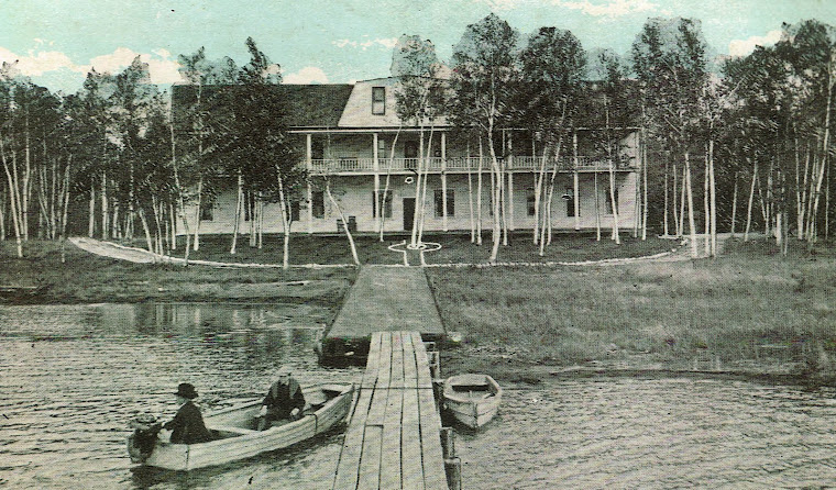
Historic Birch Lodge

Historic Birch Lodge
Historic Birch Lodge, Trout Lake, MI
Showing posts with label Area Attractions. Show all posts

Tuesday, April 2, 2013

Whitefish Bay Scenic Byway, Bay Mills, MI (Part 2)

Print Friendly and PDF Welcome to the second installment of the Whitefish Bay Scenic Byway tour, which we took last fall.  This section begins west of Bay Mills, MI and continues west along Lakeshore Dr. to M-123.

Pendills Creek National Fish Hatchery, Bay Mills, MI
The Pendills Creek Hatchery, operated by the U.S. Fish and Wildlife Service raises lake trout for stocking programs in Michigan, Indiana, Illinois, and Wisconsin.  Tours are available by calling ahead. Some very interesting illustrated signs in the parking lot.   Stop and read them for some interesting information on the trout hatching and stocking program. 
Mouth of Pendills Creek at Whitefish Bay, Bay Mills, MI
 There is also an access point to Lake Superior across the road with a roadside park along Pendills Creek.  You can walk a short trail out Lake Superior at the mouth of Pendills Creek


"The Narrows" is an area east of Naomikong Point where the road is very close to the lake.  Searching for a reason for the name, I found only one reference to the narrow strip of land between the road and lake.

  The term seemed nautical to me, and looking at a map, I noticed that in this area, the deep lake waters come very close to the shore, only a narrow strip of shallows between them and land.  This might be of interest to note for any who might be temped to swim here.  The waters will be colder, and perhaps more dangerous that at "The Shallows".
Naomikong Point Overlook, Whitefish Bay, MI

North Country Trail, Naomikong Point, MI
Naomikong Point and Naomikong Overlook are an access point to the North Country Trail.  The name is from the Native American word for shoal point.  It forms the eastern boundary of the Tahquamenon Bay.

 The point itself is well north of the road, but the overlook is lovely, and there is a trail with stairs that will lead you to the water, this is a long walk, so be prepared to hike at least a couple of miles.  Or you can access the North Country trail at several other points along the drive.  You may also walk the trail to the south of the road which leads to Naomikong Pond.  This is a stocked trout pond.


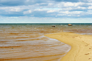
"The Shallows" is a beautiful boulder studded stretch of beach with shallow water extending well out into the lake.  This area was noted by the native Americans as an excellent fishery. 
Beach at "The Shallows", Whitefish Bay, MI

The shallow waters will warm quickly, and beach goers might take this into consideration.
We enjoyed the long stretch of beach and the rocks here.  A good place for photos.

  The North Country Trail passes along the beach here. 

North Country Trail, Whitefish Bay, MI


"The Bark Docks" is another lake and North Country Trail access point.
It actually runs parallel the road along the beach.  You can walk short or longer segments to see interesting bird and plant species. 
Beach at "The Barkdocks", Whitefish Bay, MI

  Don't look for docks here, you won't see them.  I believe the name may reference the location of docks used by loggers to ship hemlock bark.

 This was much valued for its tannic acid, and used extensively in tanning leather.
All is gone now, but another great place to access the lake, and another wonderful sandy shore. 

Bald Eagle, Whitefish Bay, MI

This was the last stop on our tour, as the Byways pulls away from the shore as it approaches it's end at the intersection  of M-123.  It was at this point also, that we spotted the eagle, perhaps bidding us goodbye and beckoning us to return again.  We will, I hope you do too.

Thursday, March 28, 2013

Whitefish Bay Scenic Byway, Bay Mills, MI ( Part 1)

Print Friendly and PDF
Whitefish Bay Scenic Byways Map, Bay Mills, MI
Whitefish Bay Scenic Byway Map
Many staying at Birch Lodge, in Trout Lake, MI visit Tahquamenon Falls Park.  However, another drive not to miss is a trip along Michigan's Whitefis Bay Scenic Byway, less than an hour a way.

Whitefish Bay Scenic Byway runs 27 miles between Bay Mills, MI and M 123 south of Paradise. This route follows along the south shore of Lake Superior.  There are a number of scenic and historic sites to enjoy.  The beaches are numerous, and the crowds are few, offering an opportunity to leave the crowds behind and enjoy the serenity of Lake Superior.

You could easily plan one day to see the historic sites, and return another day to hike segments of the North Country Trail and enjoy the shore. (Toilet facilities are situated along the route for your convenience.)  Pack a lunch or some snacks as much of this area is withing the Hiawatha National
Forest, and there are no places to stop once out of Bay Mills.  This tour begins at Brimley, MI, and proceeds to the west of Lakeshore Drive. (This is also FH 3150 and FH 42.)   

Spectacle Lake, Bay View, Mi
Spectacle Lake, Bay Mills, MI


Spectacle Lake Overlook.

Just a short way from the Bay Mills Indian Cemetery, is a turn off for the Mission Hill/Spectacle Lake Overlook.  It climbs the steep, tall (roughly 300') wood sand dunes via a narrow roadway to the top.  We found this road a little harrowing, but it was worth the trip to the top.
Road to Spectacle Lake Overlook, Bay Mills, MI


 The view is wonderful, and there are some hiking trails along the steep dune edge.

Hiking Trail, Spectacle Lake, Bay Mills, MI
Hiking Trail at Spectacle Lake Overlook


  Mission Hill Cemetery is across the small overlook parking area.


Point Iroquois Lighthouse, Bay Mills, MI


The Point Iroquois Lighthouse is located just west of Bay Mills, on Iroquois Point.


  It is listed on the National Register of Historic Places, and is open for tours.


It is the subject of of an earlier blog.   I hate to repeat myself!   Read about it here:  Point Iroquois Lighthouse.


The Big Pines Picnic Area is a beautiful  day use area on the lakeshore.  The area is covered in large red pine.  Toilets and grills are available, and the beach is sandy.

Least your eyes get weary, I think that is enough for now.   Check the next blog for our next exciting installment.....


Saturday, March 23, 2013

Point Iroquois Lighthouse, Bay Mills, MI

Print Friendly and PDF
Point Iroquois LIghtstation, Bay Mills, MI

The Point Iroquois Lighthouse is located just west of Bay Mills, at Iroquois Point on Lake Superior.
This is about 40 minutes from Birch Lodge and Trout Lake, MI  The point itself, got its name from a battle between the Iroquois who had invaded the area in search of control of trade and fur trapping.  They were vanquished here at this place by the local Ojibwa.  This significant battle stopped the western progression of the Iroquois.  It was documented that in the 1700's a fur trader could still see human bones on the beach.
Beach at Point Iroquois Lighthouse, Bay Mills, MI
Beach at Point Iroquois

The first lighthouse on this site was built in 1855, two years after the Soo Locks were begun.  It was built to guide ships from Lake Superior into the St. Mary's River.


The original structure was built of wood and rubble, and stood 45 feet tall.  It was equipped with a Fresnel Lens.


 By 1867 the quality of the structure was questioned, and a new lighthouse and keepers home were planned.
Point Iroquois Lighthouse, Bay Mills, MI

The current lighthouse dates from 1870.  It is a white cape cod style structure, and has a 665 foot tall tower.  It operated until 1962 when it's function was replaced by the Canadian operated light at the mouth of the St. Mary's River.  In 1975 this light was placed on the National Register of historic Places.  It is currently part of the Hiawatha National Forest

.Daily tours are offered at the Point Iroquois Lighthouse, and you may climb the tower to view Lake Superior. Summer hours are from 10am to 5pm daily. 

Lake Superior at Point Iroquois LIght, Bay Mills, MICurrently they are searching for a volunteer caretaker to live at and care for the lighthouse.  They ask a minimum commitment of one year.  Are you interested?  Here is a link to click:
Point Iroquois Lighthouse Facebook 
Hasn't everyone always  secretly wanted to live at a lighthouse on Lake Superior??

Monday, October 29, 2012

The Centennial Cranberry Farm

Print Friendly and PDF
Centennial Cranberry Farm, Paradise, MI
Thinking about craisins for my oatmeal got me thinking about the Centennial Cranberry Farm up on Whitefish Point.  Whitefish Point is only about 45 minutes north of Birch Lodge on M 123, so we followed the sign pointing off M 123 and went for a visit.
Lake Superior Dune, Whitefish Point MI

The farm is located on a natural cranberry bog adjacent the dunes along Lake Superior's south shore.  It truly feels in a world of its own, with only wild lands bordering it to the west, it seems an outpost.

Cranberries, Whitefish Point, MI

Currently there are thirteen acres of improved fields planted with cultivated strains of cranberries.

Centennial Cranberry Farm was founded in 1876 by John Clarke, the great-uncle of the current owner Loren House.  He had visited the area while working as a fisherman in  1873, and felt that the berries here could be cultivated and turned into a business. 

We met Loren in the gift shop, and were disappointed to learn that the hot dry summer had devastated the crop.  So few berries were produced that they had not been harvested.  He graciously let us wander through the cranberry fields, and told us about the video, equipment and old photos on display for visitors.

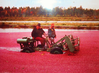
For harvest, the fields are usually flooded by pumping water from a small lake bordering the fields, which allows the berries to float to the top of the water as the mechanical harvester threshes the berries off of the vines.

  A boom is then deployed on the water to collect the raft of berries, which are then scooped up a conveyor onto a truck.  The berries are then shipped to Wisconsin for further processing.


Loren said he is thinking of retiring, and is hoping the grandsons will continue to farm the bog, but he is a little uncertain they will continue the business.  I hope they will---this is really a fascinating place to see.   It made our visit with him kind of like the cranberries--a little bittersweet.

Vintage photos and harvest photos curtesy of the Centennial Cranberry Farm....oh and Bill thinks he might make a cranberry farmer.....

Tuesday, June 19, 2012

Tahquamenon Falls and the Duck Lake Fire

Print Friendly and PDF


About a week ago now, we had heard that the Duck Lake Fire had been largely contained and that the campground at the Lower Tahquamenon Falls was open again to the public.  We had a nice weekend, and Bill's cousins were visiting, so we took a trip up to the falls to see what it was like. 

At one point they were speaking about evacuating Paradise, and we were braced to see burned terrain.  We were very pleased to see no sign of the fire at all in the Paradise area, or along the road out to the falls. 

At the entrance to the Upper Falls Park, we saw a lighted sign along the road warning about the wildfire in the area.

 The fire crews were out working on hot spots, and the roads had not all been opened.  (Since our visit, we have heard that the roads are open, but the forest roads are in rough shape from the vehicles fighting the fire--so if you are planning a trip into the fire area beware.   Also, the area is already starting to green up after the burn!)


The Falls were as usual a fantastic sight, and it was a relief to find all is as usual in the Falls area.


 So if you were lamenting the loss due to the fire, be aware that not all has been lost, there is still plenty of the U.P. that is just fine....come and see for yourself!

Saturday, May 7, 2011

The North Country Trail

Print Friendly and PDF North Country Trail Sigh There are several access points to the North Country Tail within a dozen miles of Birch Lodge and Trout Lake, MI. The North Country Trail is longer than the Appalachian Trail and traverses seven states, a long segment of which passes through Michigan.

North Country Trail Blue Markings
This trail system was developed through the National Parks system, and is largely constructed and maintained by volunteers. In our area the trail has good signage at the points where it crosses area roads, and the passage way of the trail itself is designated by light blue paint marks on trees along the trail.


In the Eastern Upper Peninsula, the trail runs almost parallel to M-123 from Lake Michigan to Lake Superior. Segments of the trail are described by the group of volunteers that maintain it through the Hiawatha Shore to Shore trail association.


This week, after working at the lodge we took a drive on H-40 east of town, to the access point at Trout Brook Pond, which by the way is stocked with trout. This is HSS Trail Head #3, and this segment of the trail goes to Soldier Lake about 18 1/2 miles to the north. (The HSS note that this segment of the trail provides good areas for morel mushrooms!)

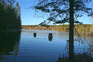
Trout Brook Pond
At first, we followed a two track in through the pines to camp site on the south west point of the pond (really a lake). What a beautiful spot! The trail crossed a foot bridge, and climbed a hill overlooking the pond.


We next stopped at the Trail Head a little further to the east, an improved road with a boat ramp. This provides a good parking area and easy access to the trail between the pond and Biscuit Creek, which lies about a 1/4 mile to the north. (Biscuit Creek is also a designated trout stream.)
Biscuit Creek
Biscuit Creek
After exploring the area a bit, the sun was getting low so we headed back to Birch Lodge. Checking the map, we decided to go the "scenic route" via Spur Road, which crosses Biscuit Creek over an "improved" road, and turning west on the sandy two track which follows the Pine River.

North Country Trail Trout Brook Pond Map
Oddly, although we have done a great deal of exploring the woods in this general area, we had never visited the Pine River. There are a number of nice access points to the Pine River along this trail, the river is well down-cut, and there are beautiful stands of pine along the bluff edge. At one point, we discovered evidence of an old logging dam. It is a very beautiful area, but it was getting late. We will have to pack a lunch, and hike the trail and explore this area another day.

Pine River, Chippewa Co., MI

Saturday, April 23, 2011

Whitefish Point, April 2011

Print Friendly and PDF
The weather was nice so we took a quick trip to see what was happening up on Whitefish Point, north of Paradise, MI. At Birch Lodge, the water from the river at the end of the motel drains into Big Trout Lake, and has kept an area of water open in front of the motel and lodge. We noticed some Common Mergansers, Tundra Swans, and Canada Geese there, and thought we should see what birds were visible at Whitefish Point.

Although the snow was pretty well off the ground in Trout Lake, MI, just an hour to the North, the snow was still about 7-8" deep. The sunny blue sky also abated, and a strong wind had picked up from the north off of Lake Superior. Whitefish Point is always one of my favorite places to go. As you approach Whitefish Point the vegetation seems almost tundra like, but just south of the Tahquamenon River this gives way to beautiful piney dunes.


We were hoping to see some migratory birds at the point, but not much was flying. The trails were roped off to discourage foot traffic. They were doing night time netting and banding of owls, and did not want their pathways disturbed during the day. The observatory gift shop was closed. We still enjoyed walking out to the lake shore to the North. The beautiful stones always seem other-worldly. On the horizon, beyond the edge of the ice, a freighter was making way on Lake Superior.


The Whitefish Point Light is a functional light as well as an interpretive museum. Also closed on our visit, but this wasn't our destination today, and we will return another day.


Our efforts to see migratory birds were rewarded when we stopped along the mouth of the Tahquamenon River.


Small flocks of mergansers and waterfowl were visible on the bends of the river.


But our favorite sighting was of this Great Egret wading along the drainage ditch right along the road.


The birds are definitely on the move, and we will return in a few weeks to do some more serious birding then.